Snowclim
What is snowclim?
The SnowClim Model is a physics-based snow model that incorporates key energy balance processes necessary for capturing snowpack spatiotemporal variability, including under future climate scenarios, while optimizing computational efficiency throughout several empirical simplifications. In addition to the model which is available in MATLAB, several datasets exist that cover the pre-industrial, modern, and future climate at a 210-m horizontal resolution across the western US.
Reference:
Lute, A. C., Abatzoglou, J., and Link, T.: SnowClim v1.0: high-resolution snow model and data for the western United States, Geosci. Model Dev., 15, 5045–5071, https://doi.org/10.5194/gmd-15-5045-2022, 2022.
Reference:
Lute, A. C., Abatzoglou, J., and Link, T.: SnowClim v1.0: high-resolution snow model and data for the western United States, Geosci. Model Dev., 15, 5045–5071, https://doi.org/10.5194/gmd-15-5045-2022, 2022.
Datasets
|
Primary Climate Variables: Monthly maximum, mean, and minimum temperature, dewpoint temperature, precipitation accumulation, downward surface shortwave radiation, wind-speed
|
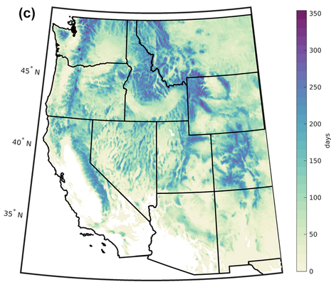
Snow variables: Annual maximum SWE, largest snowfall event, maximum snow depth, monthly maximum, mean, and minimum SWE and snow depth, snowfall, date of annual maximum SWE, date of largest snowfall event, date of snowcover end, date of snowcover start, snow cover days, snow duration days, snow free days
|
Methods
SnowClim is a computationally efficient process-based snow model. The model was evaluated and calibrated at Snowpack Telemetry (SNOTEL) sites across the western United States (US), achieving a site-median root-mean-squared error for daily snow water equivalent (SWE) of 64 mm, bias in peak SWE of −2.6 mm, and bias in snow duration of −4.5 days. Positive biases were found at sites with mean winter temperature above freezing where the estimation of precipitation phase is prone to errors. The model was applied to the western US (a domain covering 3.1 million square kilometers) using newly developed forcing data created by statistically downscaling pre-industrial, historical, and pseudo-global warming climate data from the Weather Research and Forecasting (WRF) model. The resulting product is the SnowClim dataset, a suite of summary climate and snow metrics, including monthly SWE and snow depth, as well as annual maximum SWE and snow cover duration, for the western US at 210 m spatial resolution (Lute et al., 2021). The physical basis, large extent, and high spatial resolution of this dataset enable novel analyses of changing hydroclimate and its implications for natural and human systems.
The SnowClim Dataset consists of climate forcing data for and snow outputs from the SnowClim Model. Climate forcing data was downscaled from 4 km climate data from the Weather Research and Forecasting (WRF) model (Rasmussen and Liu, 2017) to ~210 m across the contiguous western United States. Climate forcings were downscaled from WRF directly for a present day (2000-2013) period and a thirteen year pseudo global warming scenario reflecting conditions between 2071-2100 under RCP 8.5. Climate forcings were prepared for a third time period by perturbing present-day downscaled climate data by the multi-model mean from CMIP5 to reflect conditions under pre-industrial conditions (1850-1879).
The SnowClim Dataset consists of climate forcing data for and snow outputs from the SnowClim Model. Climate forcing data was downscaled from 4 km climate data from the Weather Research and Forecasting (WRF) model (Rasmussen and Liu, 2017) to ~210 m across the contiguous western United States. Climate forcings were downscaled from WRF directly for a present day (2000-2013) period and a thirteen year pseudo global warming scenario reflecting conditions between 2071-2100 under RCP 8.5. Climate forcings were prepared for a third time period by perturbing present-day downscaled climate data by the multi-model mean from CMIP5 to reflect conditions under pre-industrial conditions (1850-1879).
Data limitations
- SnowClim does not account for vegetation-snow interactions and associated heterogeneity in such patterns.
- SnowClim does not account for snow redistribution by wind and blowing snow sublimation or topographic redistribution of snow on a landscape
Copyrights
To the extent possible under law,
the authors
has waived all copyright and related or neighboring rights to
SnowClim.
This work is published from:
United States.

Updates to data products (recalls, new variables) will be highlighted here:
Lute, A. C., Abatzoglou, J., and Link, T.: SnowClim v1.0: high-resolution snow model and data for the western United States, Geosci. Model Dev., 15, 5045–5071, https://doi.org/10.5194/gmd-15-5045-2022, 2022.